- 2021
- December (1)
- March (87)
- February (60)
- January (35)
- 2020
- December (109)
- November (111)
- October (109)
- September (114)
- August (22)
- July (129)
- June (116)
- May (93)
- April (106)
- March (114)
- February (53)
- January (31)
- 2019
- December (37)
- November (72)
- October (52)
- September (43)
- August (65)
- July (55)
- June (14)
- May (55)
- April (72)
- March (28)
- February (1)
- January (12)
- 2018
- December (49)
- November (45)
- October (44)
- September (31)
- August (61)
- July (46)
- June (48)
- May (33)
- April (61)
- March (53)
- February (45)
- January (50)
- 2017
- December (46)
- November (56)
- October (60)
- September (20)
- August (56)
- July (61)
- June (58)
- May (28)
- April (44)
- March (57)
- February (54)
- January (42)
- 2016
- December (55)
- November (70)
- October (73)
- September (24)
- August (50)
- July (47)
- June (61)
- May (19)
- April (48)
- March (47)
- February (33)
- January (45)
- 2015
- December (43)
- November (39)
- October (53)
- September (55)
- August (19)
- July (47)
- June (28)
- May (26)
- April (54)
- March (55)
- February (29)
- January (30)
- 2014
- December (26)
- November (48)
- October (44)
- September (30)
- August (28)
- July (30)
- June (23)
- May (53)
- April (30)
- March (25)
- February (31)
- January (16)
- 2013
- December (23)
- November (29)
- October (34)
- September (12)
- August (15)
- July (23)
- June (12)
- May (24)
- April (12)
- March (14)
- February (22)
- January (15)
- 2012
- December (16)
- November (30)
- October (28)
- September (4)
- August (14)
- July (15)
- June (3)
- May (5)
- April (7)
- March (14)
- February (8)
- January (9)
- 2011
- December (8)
- November (17)
- October (17)
- September (16)
- August (11)
- July (14)
- June (8)
- May (16)
- April (12)
- March (20)
- February (11)
- January (7)
- 2010
- December (3)
- November (8)
- October (18)
- September (19)
- August (12)
- July (16)
- June (21)
- May (15)
- April (12)
- March (15)
- February (22)
- January (11)
- 2009
- December (13)
- November (16)
- October (10)
- September (12)
- August (5)
- July (15)
- June (15)
- May (9)
- April (15)
- March (6)
- February (14)
- January (6)
- 2008
- December (9)
- November (5)
- October (2)
- September (2)
- August (1)
- July (1)
- June (1)
- April (4)
- February (1)
- January (3)
- 2007
- December (1)
- November (2)
- October (6)
MAP OF POTENTIAL LANDSLIDES
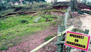
South Serbia isn’t threatened by landslides.
Geologists Milos Marjanovic and Uros Djuric made a map of potential landslides, which might occur in South Serbia after the heavy rains.
It was explained that the map referred to the so-called deep landslides, which are different from those that occurred recently.
The most vulnerable parts of the country in that respect are Sumadia and Western Serbia, while South Serbia is one of the parts where the possibility of landslides is small or very small, although the only areas considered in detail were those with overflowing rivers.
The development of the map was influenced by the geological make-up of terrain, distance from the flood zone, distance from drainage, slope of terrain and relief energy.
Source: South News and Coordination Body